


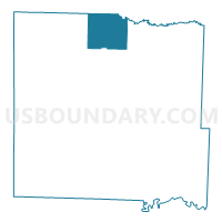
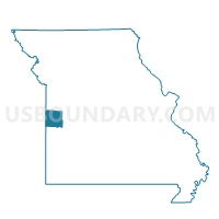
Adrian North Voting District, Bates County, Missouri
About
Outline

Summary
| Unique Area Identifier | 607090 |
| Name | Adrian North Voting District |
| County | Bates County |
| State | Missouri |
| Area (square miles) | 31.48 |
| Land Area (square miles) | 31.18 |
| Water Area (square miles) | 0.30 |
| % of Land Area | 99.06 |
| % of Water Area | 0.94 |
| Latitude of the Internal Point | 38.43822440 |
| Longtitude of the Internal Point | -94.34503320 |
Maps

Graphs
Select a template below for downloading or customizing gragh for Adrian North Voting District, Bates County, Missouri


Neighbors
Neighoring Voting District (by Name) Neighboring Voting District on the Map
- Adrian South Voting District, Bates County, MO
- No. 4 - Austin Voting District, Cass County, MO
- No. 5 - Austin Voting District, Cass County, MO
Top 10 Neighboring County Subdivision (by Population) Neighboring County Subdivision on the Map
- Deer Creek township, Bates County, MO (2,349)
- Austin township, Cass County, MO (2,096)
- Mound township, Bates County, MO (841)
- East Boone township, Bates County, MO (538)
- Grand River township, Bates County, MO (312)
- Elkhart township, Bates County, MO (299)
- Shawnee township, Bates County, MO (271)
Top 10 Neighboring Place (by Population) Neighboring Place on the Map
Top 10 Neighboring Unified School District (by Population) Neighboring Unified School District on the Map
Top 10 Neighboring State Legislative District Lower Chamber (by Population) Neighboring State Legislative District Lower Chamber on the Map
Top 10 Neighboring State Legislative District Upper Chamber (by Population) Neighboring State Legislative District Upper Chamber on the Map
Top 10 Neighboring 111th Congressional District (by Population) Neighboring 111th Congressional District on the Map
Top 10 Neighboring Census Tract (by Population) Neighboring Census Tract on the Map
- Census Tract 701, Bates County, MO (5,248)
- Census Tract 702, Bates County, MO (4,411)
- Census Tract 612, Cass County, MO (3,983)